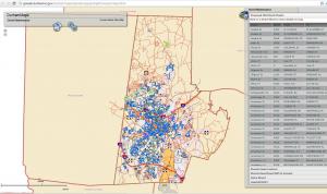
The City of Durham Department of Public Works has provided cutting edge project communication by integrating GIS with Project Controls software (Oracle Primavera) in order to provide open visibility to citizens, government officials, project team members and other outside interested parties. The City took several years to prepare and stage the data with coordination in engineering, contract management and technology. The resulting effort is a real-time application called Operation Green Light - Durham Street Repaving Progress. The system allows users to track when their street will be (or was) repaved by quickly zooming in on the area of interest and highlighting the street in question. Other navigation capabilities include sorting by planned or in process project and the ability to search by typing in your street name. In addition, the interactive query-based web application shows all of the streets in the City, whether they are maintained by the City or the North Carolina Department of Transportation (NCDOT), and their repaving schedule and status. The status is routinely updated weekly; however, the data could be refreshed instantly, and many times during a day if that proved to be necessary.
This has also led to the establishment of project expense data warehouse (DataMart) which among other attributes has keys which point to the various GIS feature classes depending on the type of infrastructure project. The structure of the DataMart was designed in such a way to allow it to be used to identify geospatial trends in the frequency and type of repairs that are being performed on the City streets. Durham is bisected by an ancient geologic feature known as the Triassic Basin which has soils with poor structural characteristics. This is one of the geospatial features of interest when looking for trends, along with year constructed, average daily vehicle counts, the initial pavement construction standards, bus routes and so on.
Webinar Learning Objectives
- Acquire knowledge about how to structure mechanisms for sharing data between Contract and Project Management Systems (Oracle Primavera or otherwise) and Geographic Information Systems.
- Conceptualize about how the methods for geospatial data analysis described in the presentation might be utilized in your organization.
- Discuss how web-based technologies when integrated with Geographic Information Systems and Contract and Project Management Systems can be used to keep the public informed about the status of projects in their City.
The Background
Beginning in 2007, the City of Durham Department of Public Works accumulated five years of experience with advanced state-of-the-art contract and project management systems used to administer City construction projects. Since that time approximately $100M in projects has passed through the system including but not limited to street repair, reconstruction and repaving, to new sidewalk construction and repair, storm water infrastructure planning and replacement, and water/sewer extensions
Before beginning the deployment, one of the key objectives identified was the integration and data flow between the contract/project management software (CPMS) and the geographic information system (GIS). The need for this integration was driven by the public sector which frequently asks questions about the geospatial distribution of resources across the City neighborhoods and districts. This type of analysis is fluidly accomplished by GIS, provided that the data structures are in place, and the data has been collected by CPMS in such a way that it can be pushed or pulled (downloaded or uploaded) to (or from) GIS using automated systems.
Presenters:
Michael Hughes – City of Durham Public Works (CDP Customer)
Stephen Cole – Stephen Cole Consulting (CDP Development Partner)